La Niña pattern emerges, likely enhancing Atlantic hurricane activity and western drought
(NewsNation Now) — The National Oceanic & Atmospheric Association (NOAA) announced Thursday that a La Niña pattern has formed in the central Pacific Ocean which often means a more active hurricane season and a drier southwest United States.
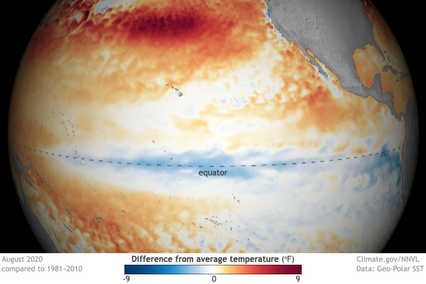
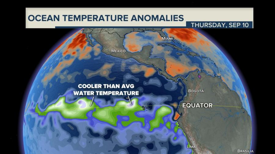
La Niña, which is the opposite to the well known El Niño, is simply cooler than average waters off the eastern equatorial Pacific. Just a degree or two can have major affects on global weather patterns. The La Niña pattern will continue to enhance the record breaking Atlantic hurricane season, and create dry conditions across the southern and southwestern United States possibly exacerbating an already exceptional wildfire season.
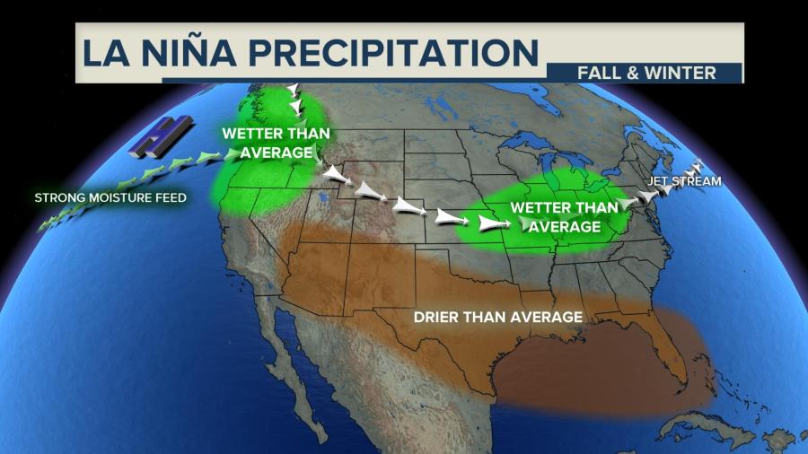
A natural cooling of certain parts of the equatorial Pacific, La Nina sets in motion a series of changes to the world’s weather that can last months, even years. This one so far is fairly weak and is projected to last through at least February but may not be the two-to-three-year type sometimes seen in the past, said NOAA Climate Prediction Center Deputy Director Mike Halpert.
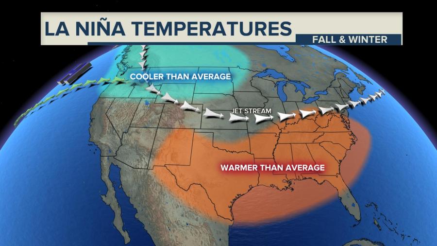
La Niñas and El Niños, along with neutral conditions are called El Niño Southern Oscillation or ENSO. The changes that happen during ENSO events aren’t certain things. Different sizes and types trigger varying effects and some years the common impacts just don’t show up. It’s more an increased tendency than an environmental edict.
The jet stream that steers daily weather shifts a bit in the winter. That generally means a drier winter in the South and Southwest from coast to coast. It usually means a bit warmer in the South, too. It gets wetter in the Pacific Northwest and the Ohio Valley in the winter and colder in the Northern tier in the winter.

One of the clearest connections that meteorologists follow during a La Nina event is a more active Atlantic Hurricane season with more and perhaps stronger storms. An El Nino means fewer, weaker storms.
That’s because one of the key ingredients for storm formation and strengthening is what’s happening to the winds near the tops of storms, University of Miami hurricane researcher Brian McNoldy said. An El Nino means more strong crosswinds that can decapitate storms, but a La Nina means fewer, allowing storms to grow.
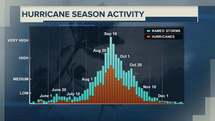
Thursday is the historical peak of hurricane season and the Atlantic is incredibly active. In addition to Tropical Storms Paulette and Rene, which set records for the earliest 16th and 17th named storms, we are monitoring four other disturbances, two near the United States, that could develop into named storms in the next five days.
Still, when it comes to seasonal forecasts in places like California, if meteorologists can get only one piece of information, they would want the ENSO status, according to Stanford University climate scientist Noah Diffenbaugh.
“La Nina is not a good sign for the wildfire outlook,” said Diffenbaugh.
However, he added that it’s mostly a potential bad sign for next year’s wildfire season because it makes California’s winter wet season drier, setting the stage for dry conditions when fires start in 2021.
Meteorologists don’t quite know enough about what La Niña does in the fall to say what it means for the current record bad California wildfire season, according to Diffenbaugh. He said for the next few months, what matters most is when the fall rains and offshore winds begin, not La Niña.
One good thing about a Fall-Winter La Niña event is the reduction severe weather during the winter time across Florida and the deep South which is referred to as “Dixie Alley” by storm chasers. The jet stream tends to retreat farther to the north. Disturbances within the jet stream are the main triggers for severe thunderstorms when they move across a warm and moisture rich air mass like you often find along the Gulf coast. The chances of severe weather will be significantly lower with the jet stream taking a more northerly track.
Watch NewsNation every night at 8/7pm Central on WGN America.


