Tornado outbreak hits the South; second round of storms moves in
TUSCALOOSA, Ala. (NewsNation Now) — Multiple tornadoes were confirmed on the ground in parts of Alabama Wednesday, as communities across the South brace for significant severe weather to continue through the evening ahead of a second round of storms.
21 tornadoes touched down across the South as of 7:30 p.m. CDT Wednesday, with most of them in the state of Alabama, NewsNation Chief Meteorologist Albert Ramon said.
The National Weather Service reported multiple tornadoes on the ground in central Alabama Wednesday afternoon, including a “large and extremely dangerous tornado” near Shelton State Community College outside Tuscaloosa around 2:40 p.m. CT.
At least two waves of storms were likely, forecasters said, and the worst might not hit until a cold front passes overnight.
Three hours into live continuing coverage after the first tornado warnings were issued in the central Alabama area, NewsNation affiliate WIAT meteorologist Griffin Hardy warned viewers shortly before 5 p.m., “We’ve got a long way to go.”
“We need to not let our guard down because we are not done with this,” WIAT meteorologist Sarah Cantey agreed.
“It’s now 5 p.m., we have a significant tornado outbreak that is in progress across Central Alabama,” Hardy said. “Over the past three hours, we’ve been watching a very big cluster of supercell thunderstorms that have tracked through the area, just warning after warning after warning that’s popped up over the last three hours.”
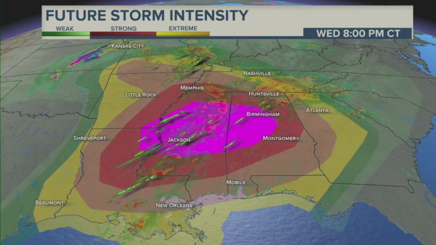
Forecasters predicted the intense tornadoes would begin Wednesday afternoon across parts of Louisiana and Arkansas before spreading eastward. The peak is anticipated for Wednesday evening across Mississippi and Alabama.
While nearly 16 million people in the Southeast could see powerful storms, the Storm Prediction Center said, a region of about 3 million stretching from southeastern Arkansas and northeastern Louisiana across Mississippi into Alabama was at high risk for the possibility of intense tornadoes that travel for miles, winds that could reach hurricane strength and hail the size of baseballs.

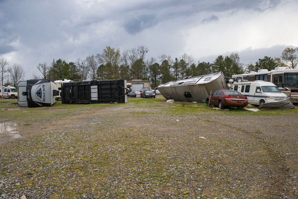
Possible tornadoes knocked down trees, toppled power lines and damaged homes in the Alabama communities of Burnsville and Moundville, where power was out and trees blocked a main highway.
“Downtown Moundville got it. Some roofs and stuff got taken off houses,” said Michael Brown, whose family owns Moundville Ace Hardware. and Building. “There’s a lot of trees down. I guess it had to be a tornado; it got out of here pretty fast.”
Additional damage was reported in Louisiana, Tennessee and Mississippi, where video showed an apparent tornado at Brookhaven. High winds blew down signs and and trees in northeast Texas, and hailstones the size of baseballs were reported near the Alabama-Mississippi line, the weather service said.
Bystander videos show tornadoes which have been spotted across Alabama throughout the day Wednesday.
Current watches and warnings:
Tornado watches Wednesday cover parts of Texas, Louisiana, Arkansas, Mississippi and Tennessee, while areas of Oklahoma and Missouri will also be at risk of severe storms.
The threats include “numerous tornadoes,” with several “intense and long track,” as well as scattered damaging winds that could reach “hurricane force” strength, the Storm Prediction Center warned.

NewsNation Meteorologist Gerard Jebaily said the wording that the Storm Prediction Center is using are descriptors that aren’t used often.
“Only in the most intense situations do we see this sort of thing,” Jebaily said.
“Today, it’s pretty much a veritable powder keg,” Jebaily explained. “This is pretty much as high of conditions as you could get at, or the most ripe of conditions you can get for severe thunderstorms where tornadoes are not just a possibility, they’re a likelihood today. And there is a very good possibility that they could be strong, large, violent, and long-track, meaning long-lived.”
More than a dozen Alabama school systems canceled classes, planned online sessions or announced early dismissals because of the threat. More could be added to the list.
Communities across the South were also urging residents to know where their closest tornado shelters are.
In Jackson, Tennessee, officials said the Carl Perkins Civic Center and McKeller-Sipes Regional Airport opened for citizens seeking shelter from severe weather starting at 9 a.m. Wednesday. Jackson is a city of about 67,000 people in West Tennessee.
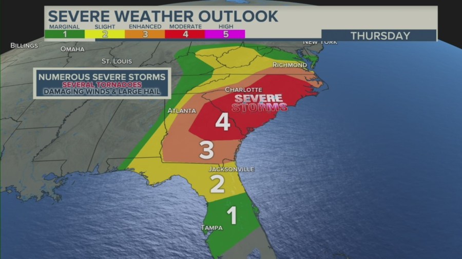
The severe weather outlook continues Thursday night for communities along the eastern coast of the U.S., including Georgia and North Carolina, as the storm system continues to cross the country.

HOW TO STAY SAFE
For those in the areas affected, Jebaily recommends making sure your cellphone is charged and accessible, and that you’re able to get weather alerts in multiple ways.
He told residents not to rely on tornado sirens, since they’re not designed to be heard indoors.
“You may be able to hear them, but they’re designed to alert people outside who may be out of reach or out of touch,” Jebaily said.
Televisions and radios are also great warning systems, he said.
Jebaily suggested that everyone get a severe weather plan in place quickly.
“You want to be able to seek shelter within a minute or two, suitable shelter,” Jebaily said. “Once a tornado watch is issued, that means you should already be thinking about plans of action that you need to be able to take.”
For residents living in mobile homes or RVS, Jebaily said vehicles are notoriously dangerous places to ride out severe weather.
“Try to think of a shelter or somewhere you might be able to go now when the tornado watch comes out,” Jebaily recommended. “So that you can be easily able to seek suitable shelter when a warning finally does get issued.”
For more information about tornado safety, visit the National Weather Service’s website.
The Associated Press contributed to this report.


