AUSTIN, Texas (AP) — Wayne Christian wanted to brag, he said, rocking in his burgundy leather chair atop the dais of the powerful Railroad Commission of Texas. Colleagues and staff were doing “a darn good job,” and people who “gripe about the environmental issues” were misinformed.
The self-congratulatory pause came during an October meeting of the agency that oversees a more than $400 billion oil and gas industry in the top-producing state of the top-producing country on a rapidly warming planet.
Christian, a former Grammy-nominated gospel singer, complained that negative media reports had obscured “the good job our staff and this industry has done for a cleaner environment, the cleanest industrialized nation on the planet.”
Then the chairman and his two fellow elected commissioners returned to their agenda and, without debate, approved 39 more requests from oil and gas companies seeking permission to burn off or vent natural gas that’s rich in methane, a powerful greenhouse gas.
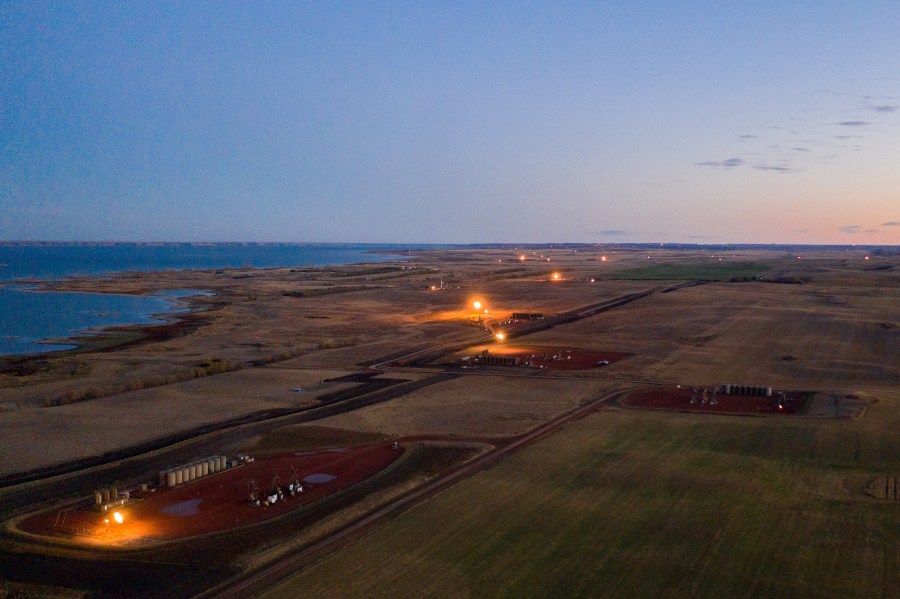
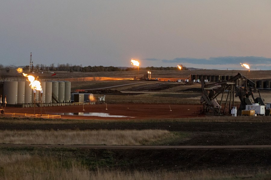
Over much of the last decade, oil and gas operators in Texas and a dozen other U.S. states have flared, or burned off, at least 3.5 trillion cubic feet of natural gas, according to an analysis of satellite data by the Howard Center for Investigative Journalism.
That amount equals more than $10.6 billion in revenue based on the market value of natural gas from 2012-2020. The industry has also directly released unknown amounts of gas into the atmosphere through a process called venting. Between them, flaring and venting release a noxious cocktail of carbon dioxide, methane and other pollutants.
Climate scientists have warned that without steep, immediate reductions in emissions of carbon dioxide and methane, the world will miss its chance to avert the deadliest and most destructive effects of climate change, which is already contributing to unprecedented wildfires, floods and other natural disasters across the planet. Epidemiologists have also linked flaring emissions to preterm births.
Flaring has surged alongside the fracking boom that’s helped producers unlock previously unreachable fossil fuels and boosted local, state and national economies over the last decade and a half. The United States now produces enough oil and natural gas to be energy independent, its volumes surpassing Saudi Arabia and Russia.
Flaring occurs mostly at oil wells, but even companies that primarily produce and sell natural gas burn off some of it. Companies argue that they flare and vent for safety and maintenance and because selling or reusing the gas is not financially feasible. The industry and its regulators even refer to this gas as “waste.” But experts say a valuable resource is being squandered because of weak regulations, ineffective tracking of flaring and venting, and a lack of economic incentives to capture and sell the gas.
“The atmosphere is a free dumping place,” said Robert L. Kleinberg, senior research scholar at the Center on Global Energy Policy at Columbia University. “It’s like throwing garbage out the window back in the Middle Ages.”

Regardless of the reasons, every act of flaring and venting releases methane, which traps heat 80 times more effectively than carbon dioxide over a 20-year period, making methane reduction one of the fastest routes to reducing global warming, experts say.
During the U.N. climate summit in Glasgow, Scotland, in November, the Biden administration unveiled its proposal to slash methane emissions by the U.S. oil and gas industry, the country’s largest industrial source of methane. While plans for a methane fee died in Congress, the Environmental Protection Agency has proposed new regulations to eliminate venting at both new and existing oil wells and require companies to capture and sell gas whenever possible.
Experts say eliminating routine flaring is technically and politically feasible, and some companies are already working toward that goal.
“No one has any reason to put methane into the air for beneficial purpose,” said Kleinberg.
But regulators are largely unaware of the amount of gas being flared and vented, the Howard Center found. It’s a blind spot that’s developed under limited federal oversight and a patchwork of state regulations, lax enforcement and inconsistent data collection.
For at least 17 years, government auditors have warned that bad data was blinding regulators to the volume of greenhouse gases being pushed into the atmosphere by the oil and gas industry’s flaring and venting.
In 2004, the U.S. Government Accountability Office recommended improved data collection and oversight. Specifically, the GAO suggested standardized reporting for flaring and venting data across all states, and the use of satellite data to improve the accuracy of flaring information. As recently as 2016, the same office warned that natural gas emissions from oil and gas production on federal land weren’t being tracked consistently.
“You can’t regulate what you don’t measure,” said Gunnar Schade, an atmospheric scientist at Texas A&M University who has used satellite data to study flaring in Texas. “We actually don’t have a good handle on what goes in the atmosphere for various reasons — some of them by design, some of them by negligence.”
The satellite flaring volumes calculated by the Howard Center, with the guidance of scientists who pioneered and used the methodology, far exceed the total reported to regulatory agencies in the 13 states designated by the U.S. Energy Department as having significant ongoing or potentially increasing flaring activity. They also far surpassed the total published by the Energy Information Administration, the U.S. Energy Department analytics agency that says it gets its data from the states.
Laws in those top-flaring states vary widely on when companies can flare or vent, whether they need prior approval, how much they can emit and if or how they’ll be penalized if they’re caught breaking the rules, the Howard Center found. All of the regulations — even the strictest — have myriad exceptions. The federal government doesn’t regulate flaring and venting except on federal and tribal lands and in federal waters.
Four of the states maintain little or no information on flaring and venting volumes, the Howard Center’s investigation found.

In those that do keep volume data, it’s based on self-reported information from oil and gas operators, some using estimations rather than metered measurements. There are few regular audits for accuracy or completeness.
“You’re totally at the whim of what the self-reporting is,” said Tim Doty, a former senior technical adviser at the Texas Commission on Environmental Quality, which is charged with maintaining air quality in what satellite data shows is the nation’s top-flaring state. “Some of the companies are trying to do the right thing, but not all the companies are trying to do the right thing.”
Satellite technology offers a way to gauge the accuracy of self-reported flaring volumes. While it comes with limitations, the technology is generally regarded as the best available, independent tool for measuring flaring volumes, though not one that state and federal regulators have adopted.
The methodology was pioneered in 2012 by Christopher Elvidge, a scientist then working at the National Oceanic and Atmospheric Administration. It uses satellites equipped with Visible Infrared Imaging Radiometer Suite instruments to detect flares from oil and gas operations and estimate the volumes of gas they burn, based on the infrared light they give off. When Elvidge later moved to the Colorado School of Mines’ Earth Observation Group, the program went with him.
Reporters at the Howard Center gathered and analyzed the satellite data for the top-flaring states from 2012 through 2020. They then compared those totals to company-reported flaring volumes collected by regulators in the same states.
The satellite data showed Texas, North Dakota and New Mexico were the top-flaring states, by large margins. It also revealed vast discrepancies compared to state-reported volumes.
Some states allow companies to report combined totals for their flaring and venting volumes, making it impossible to draw a meaningful comparison with the flaring-only volumes picked up by satellites. But in Texas, for example, satellite data indicated the volume of flared gas alone was almost double the amount reported for both flared and vented gas — raising questions about underreporting. And in Montana, the companies’ combined flaring and venting volume reports were nearly 150% higher than the flaring-only volumes detected by satellites — highlighting the unknowns surrounding venting.
The disparities persisted even in states that require oil and gas operators to separately report flaring and venting volumes, which should allow for a fair comparison against the satellite data. In North Dakota, for instance, satellites detected 25% more flaring than was reported by companies. In Wyoming, the discrepancy was roughly the same — but in the opposite direction.
Some of the discrepancies, scientists say, may result from the fact that some states don’t require companies to report every instance of flaring, and that the roving satellites don’t catch every flare, especially small or intermittent ones.
But the fact that company-reported volumes differed dramatically from those of an empirical check indicates that government data is inaccurate or incomplete and that policymakers don’t know the extent of the greenhouse gases resulting from flaring and venting, even as they attempt to craft climate change legislation.
“There’s almost been a kind of tacit agreement that we’ll accept the estimates,” said Barry Rabe, a senior fellow at the Brookings Institution who studies public and environmental policy. “Until such time that there’s political or public pressure to make those numbers more accurate, it’s easier just to look the other way.”
Reporters Aydali Campa, Jimmy Cloutier, Sarah Hunt, Mollie Jamison, Laura Kraegel, Isabel Koyama, Maya Leachman, Michael McDaniel, Andrew Onodera, Kenneth Quayle, Nicole Sadek, Isaac Stone Simonelli, Rachel Stapholz, Sarah Suwalsky, Zoha Tunio, Zach Van Arsdale and Alexis Young contributed to this story. It was produced by the Howard Center for Investigative Journalism at Arizona State University’s Walter Cronkite School of Journalism and Mass Communication, an initiative of the Scripps Howard Foundation in honor of the late news industry executive and pioneer Roy W. Howard. For more see https://azpbs.org/gaslit. Contact us at howardcenter@asu.edu or on Twitter @HowardCenterASU


