Hurricane Ian intensifies to Category 4 storm
Testing widget old system


(NewsNation) — Hurricane Ian’s extremely dangerous eyewall is making its way onshore as a Category 4 hurricane over Florida’s west coast, according to the National Hurricane Center’s (NHC) latest update.
Florida Gov. Ron DeSantis said it is now unsafe to evacuate Florida’s west coast and that all residents should shelter in place.
At 11 a.m. ET, Air Force and NOAA hurricane hunters located the eye of the hurricane about 45 miles west of Naples, Florida, moving toward the north-northeast near 9 mph.
Maximum sustained winds remain at 155 mph, meaning it is only 2 mph short of intensifying to a Category 5 storm (157 mph), with higher wind gusts, NHC said. The storm is expected to bring life-threatening storm surges, rain and power outages throughout Florida.
“It is now a Category 4 hurricane with maximum sustained winds of up to 155 mph — that is knocking on the door of a Category 5 storm,” DeSantis said at a news conference Wednesday morning.
More than 200,000 Floridians are without power, according to poweroutage.us.
“Don’t go outside in the eye of the storm,” DeSantis warns. “It’s still dangerous. There is actually a calmness if the center of the hurricane is right over you … even if it seems calm, wait to make sure that the storm has actually passed.”
The highest risk counties are from Collier County up to Sarasota County, and the most recent track has the storm making landfall in Charlotte County.
“If you are in any of those counties, it is no longer possible to safely evacuate,” DeSantis said. “It’s time to hunker down and prepare for this storm. This is a powerful storm that should be treated like you would treat if a tornado was approaching your home.”
There are over 200 shelters open in just the southwest Florida region alone.
Winds and rain have begun intensifying a day after Ian battered the western tip of Cuba, bringing down the electricity grid and leaving the entire island without power.
Ian’s forward movement slowed over the Gulf, enabling the storm to grow wider and stronger. A hurricane warning covering roughly 220 miles of the state included Fort Myers as well as Tampa and St. Petersburg, which could get their first direct hit by a major hurricane since 1921.
Forecasters said the storm surge could reach 12 to 16 feet if it peaks at high tide. Rainfall near the area of landfall could top 18 inches.
Airports in Tampa, St. Petersburg and Key West closed. Disney World theme parks and Sea World in Orlando all closed ahead of the storm.
Miami-Dade County suspended countywide transit services including Metrobus, Metrorail, Metromover and Special Transportation Services on Wednesday morning.
Tolls have been suspended along interstates to allow for faster evacuations, and bridges will be closed when certain wind speeds are met, officials said.
White House press secretary Karine Jean-Pierre said Tuesday night President Joe Biden and DeSantis discussed ways the federal government is helping Florida prepare for the hurricane and later committed to continue providing a closely coordinated storm response.
As of Tuesday night, at least 5,000 Florida Guardsmen have been activated and pre-positioned at armories across the state.
So far, 26 school districts have been closed, and more are expected to close as the storm approaches.
Residents waited upward of four hours to fill sandbags at one of three locations. Grocery store lines reached down the streets as many prepared for the storm.
Biden also declared an emergency, authorizing the Department of Homeland Security and the Federal Emergency Management Agency, or FEMA, to coordinate disaster relief and provide assistance to protect lives and property.
The president postponed a scheduled Sept. 27 trip to Florida due to the storm and NASA decided to forgo a planned Tuesday launch opportunity for its new moon rocket.
NewsNation affiliate and the Associated Press contributed to this report.
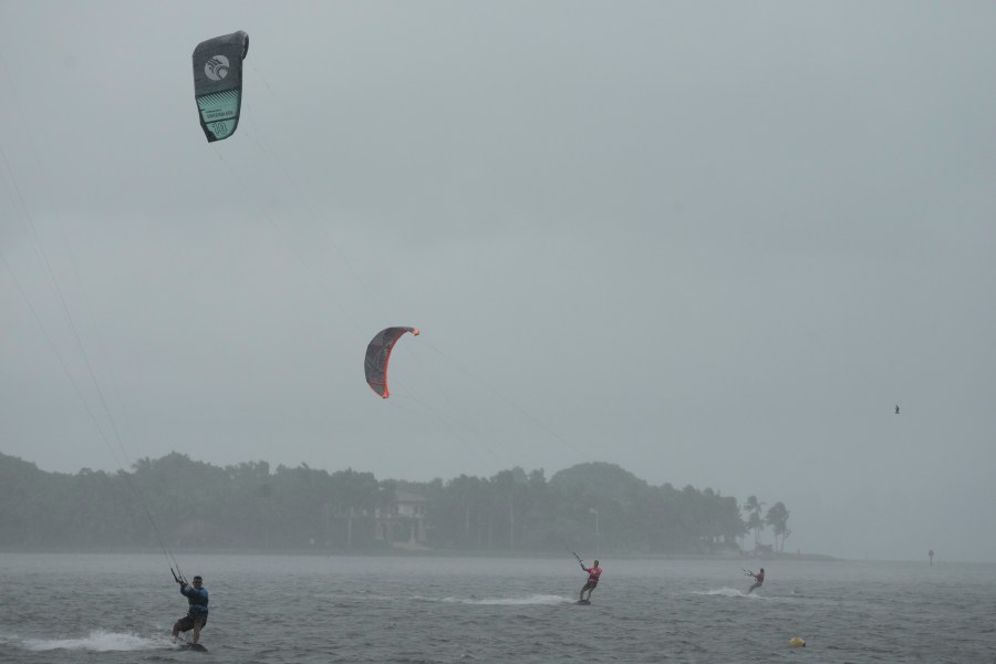
Kite surfers glide across the water as they take advantage of strong winds caused by Hurricane Ian, Tuesday, Sept. 27, 2022, at Matheson Hammock Park in Coral Gables, Fla. (AP Photo/Rebecca Blackwell) 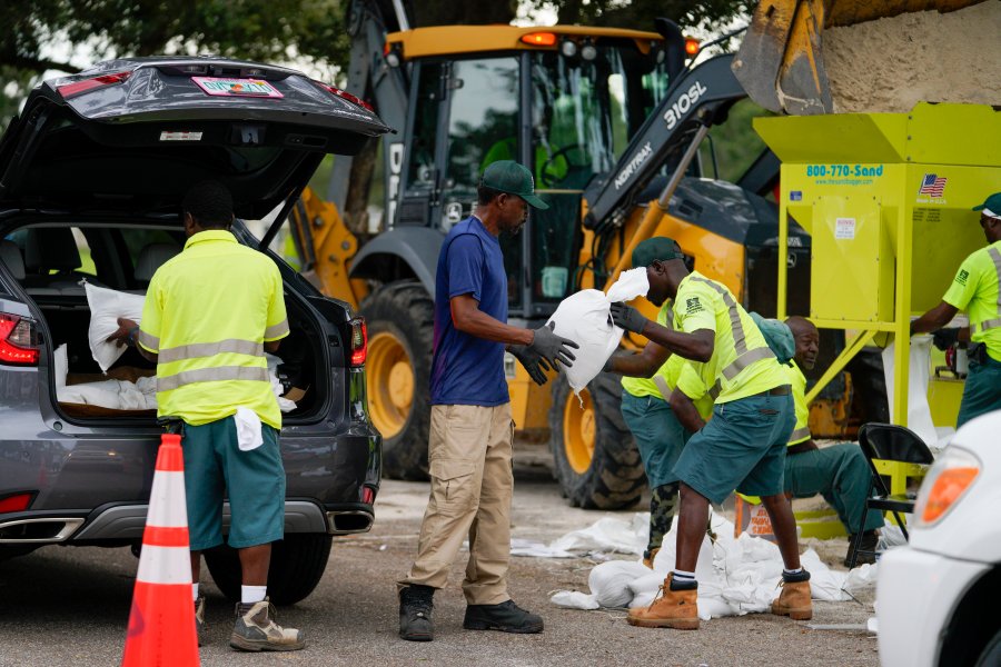
Eric Byrd hands a sandbag to Clifford Coston while working to fill people’s trucks at a sandbag station at Northwest Park, Tuesday, Sept. 27, 2022, in St. Petersburg, Fla., as Hurricane Ian approaches. (Martha Asencia-Rhine/Tampa Bay Times via AP) 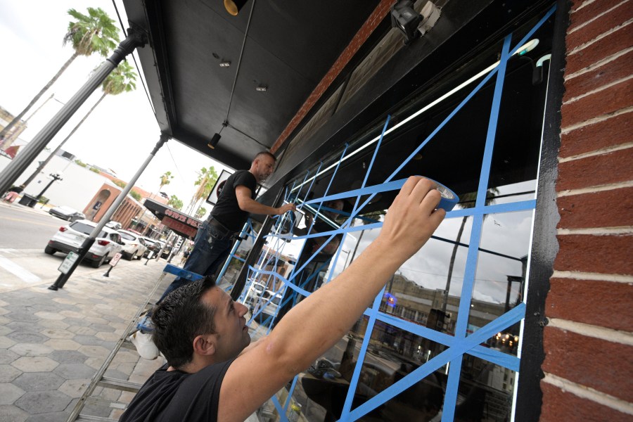
Lukas Berlajolli, above, and Tony Fazliu help tape up the windows of a pizza restaurant in the Ybor City district in preparation for Hurricane Ian as the storm approaches the western side of the state, Tuesday, Sept. 27, 2022, in Tampa, Fla. (AP Photo/Phelan M. Ebenhack) 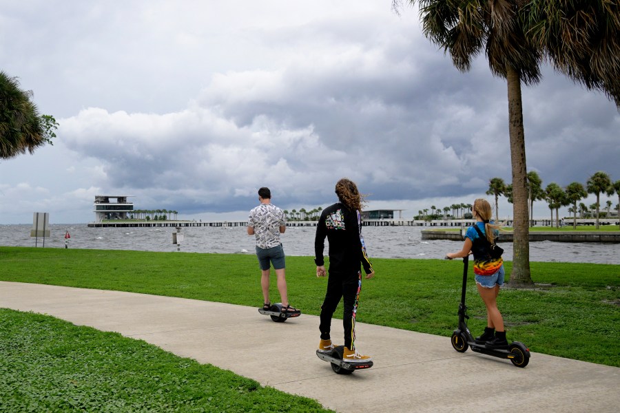
People ride along the bayfront as an outer band of Hurricane Ian approaches and kicks up the surf at Vinoy Park, Tuesday, Sept. 27, 2022, in St. Petersburg, Fla. (AP Photo/Phelan M. Ebenhack) 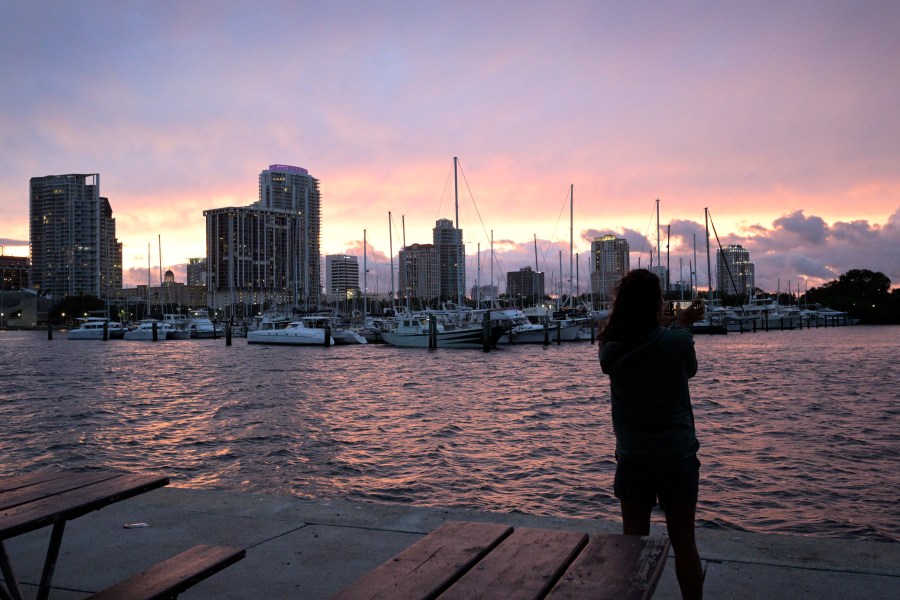
Kristi Burghdurf makes a photo of the sunset with her phone as an outer band of Hurricane Ian passes the waterfront of Tampa Bay, Tuesday, Sept. 27, 2022, in St. Petersburg, Fla. (AP Photo/Phelan M. Ebenhack) 
Guests depart the Magic Kingdom at Walt Disney World in the final minutes before the park closed early to accommodate an evening special event, Tuesday, Sept. 27, 2022, in Lake Buena Vista, Fla. Disney World, Universal Orlando and SeaWorld Orlando all announced Tuesday that they will be closed Wednesday and Thursday due to the weather conditions caused by Hurricane Ian. (Joe Burbank/Orlando Sentinel via AP) 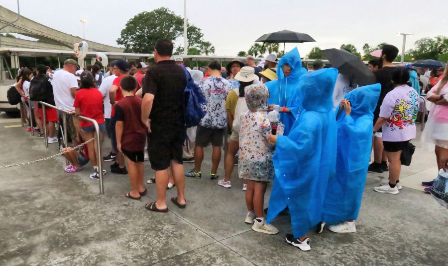
Guests wait for tram transportation at the Magic Kingdom at Walt Disney World after the park closed early to accommodate an evening special event, Tuesday, Sept. 27, 2022, in Lake Buena Vista, Fla. Disney World, Universal Orlando and SeaWorld Orlando all announced Tuesday that they will be closed Wednesday and Thursday due to the weather conditions caused by Hurricane Ian. (Joe Burbank/Orlando Sentinel via AP) 
Guests depart the ferry boat transportation at the Magic Kingdom at Walt Disney World after the park closed early to accommodate an evening special event, Tuesday, Sept. 27, 2022, in Lake Buena Vista, Fla. Disney World, Universal Orlando and SeaWorld Orlando all announced Tuesday that they will be closed Wednesday and Thursday due to the weather conditions caused by Hurricane Ian. (Joe Burbank/Orlando Sentinel via AP) 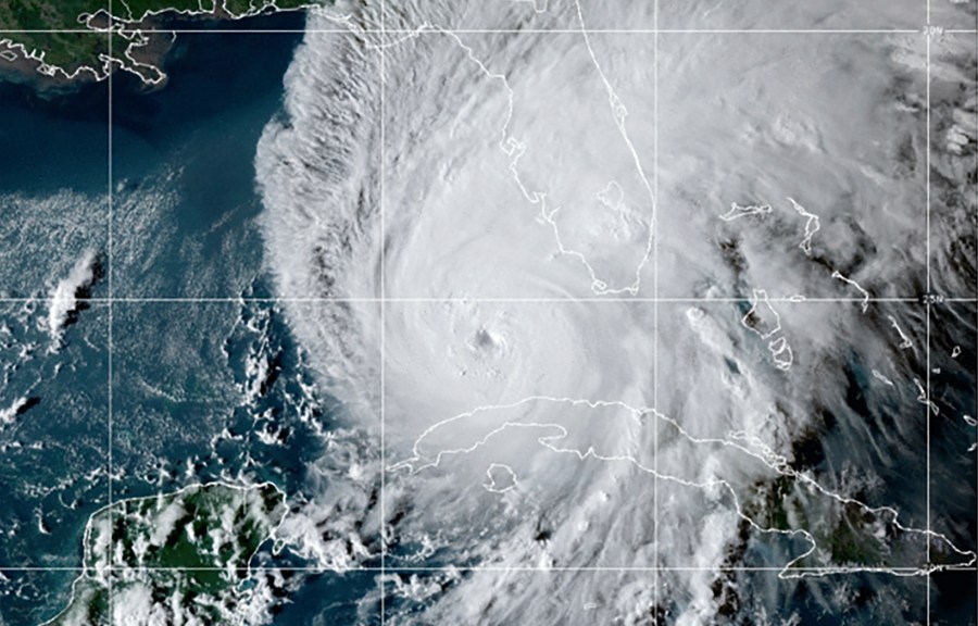
This GOES-East GeoCcolor satellite image taken at 10:10 p.m. EDT on Tuesday, Sept. 27, 2022, and provided by the National Oceanic and Atmospheric Administration (NOAA), shows Hurricane Ian over the Gulf of Mexico. Ian tore into western Cuba as a major hurricane Tuesday, knocking out power to the entire country and leaving millions people without electricity, before churning on a collision course with Florida over warm Gulf waters amid expectations it would strengthen into a catastrophic Category 4 storm. (NOAA via AP) 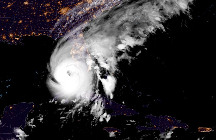
This GOES-East GeoCcolor satellite image taken at 12:41 a.m. EDT on Wednesday, Sept. 28, 2022, and provided by the National Oceanic and Atmospheric Administration (NOAA), shows Hurricane Ian over the Gulf of Mexico. Cuba remained in the dark early Wednesday after Hurricane Ian knocked out its power grid and devastated some of the country’s most important tobacco farms when it hit the island’s western tip as a major storm. (NOAA via AP) 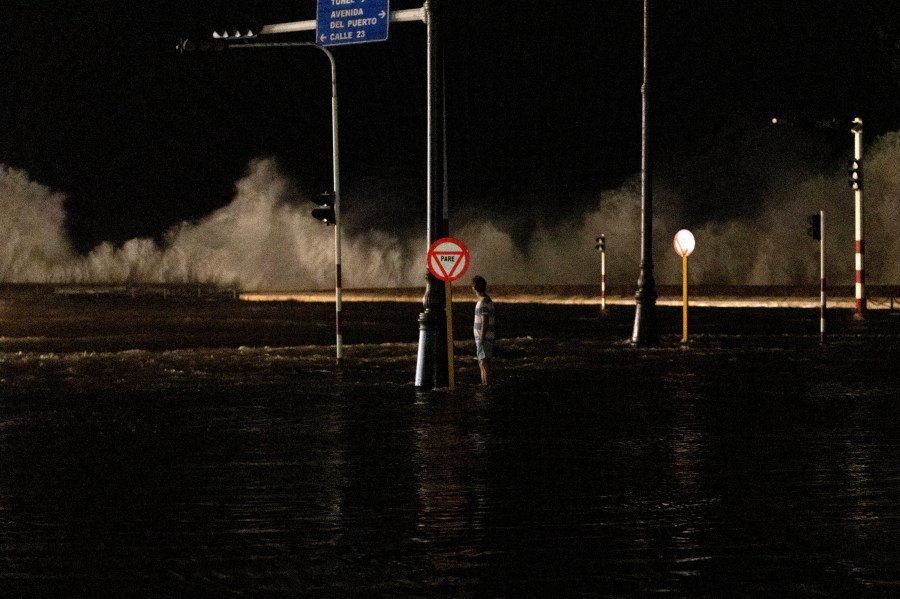
A man watches as the waves break on the boardwalk in Havana, Cuba, Wednesday, Sept. 28, 2022. Cuba remained in the dark early Wednesday after Hurricane Ian knocked out its power grid and devastated some of the country’s most important tobacco farms when it hit the island’s western tip as a major storm. (AP Photo/Ramon Espinosa) 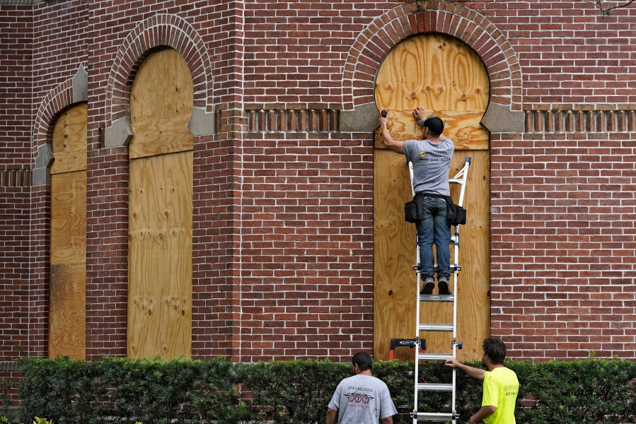
Workers from Specialized Performance Delivered 24:7 board up the windows on the historical Henry B. Plant Hall on the campus of the University of Tampa ahead of Hurricane Ian Tuesday, Sept. 27, 2022, in Tampa, Fla. Ian is predicted to make landfall somewhere on Florida’s west coast. (AP Photo/Chris O’Meara) 
A dog is walked through floodwater as the tide rise, Tuesday, Sept. 27, 2022, in Key West, Fla., as the first bands of rain associated with Hurricane Ian pass to the west of the island chain. Ian was forecast to strengthen even more over warm Gulf of Mexico waters, reaching top winds of 140 mph (225 kmh) as it approaches the Florida’s southwest coast. (Rob O’Neal/The Key West Citizen via AP) 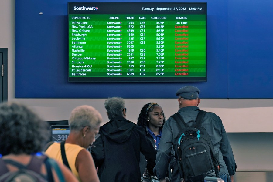
Southwest Airline passengers check into a ticket counter near a sign that shows canceled flights at the Tampa International Airport Tuesday, Sept. 27, 2022, in Tampa, Fla. The airport is closing at 5pm EST today ahead of Hurricane Ian. Ian is predicted to make landfall somewhere along Florida’s west coast. (AP Photo/Chris O’Meara) 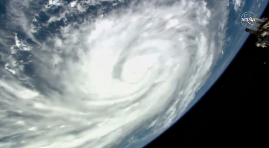
This image provided by NASA shows Hurricane Ian seen below the International Space Station as the storm was gaining strength south of Cuba and moving toward Florida at around 3pm ET on Monday, Sept 26, 2022. (NASA via AP) 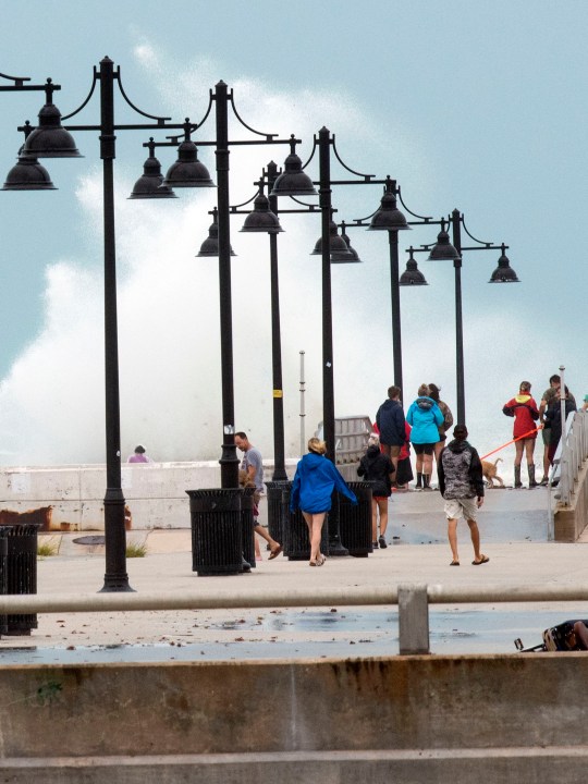
Tourists and residents stroll White Street pier, Tuesday, Sept. 27, 2022, in Key West, Fla. Hurricane Ian was forecast to strengthen even more over warm Gulf of Mexico waters, reaching top winds of 140 mph (225 kmh) as it approaches the Florida’s southwest coast. (AP Photo/Mary Martin) 
U.S. Air Force helicopters are gathered inside the Orange County Convention Center on Tuesday, Sept. 27, 2022. They were staging in preparation for Hurricane Ian, which is approaching Florida’s west coast. (Stephen M. Dowell/Orlando Sentinel via AP) 
Eastbound traffic crowds Interstate 4 as people evacuate in preparation for Hurricane Ian approaches the western side of the state, Tuesday, Sept. 27, 2022, in Lake Alfred, Fla. (AP Photo/Phelan M. Ebenhack) 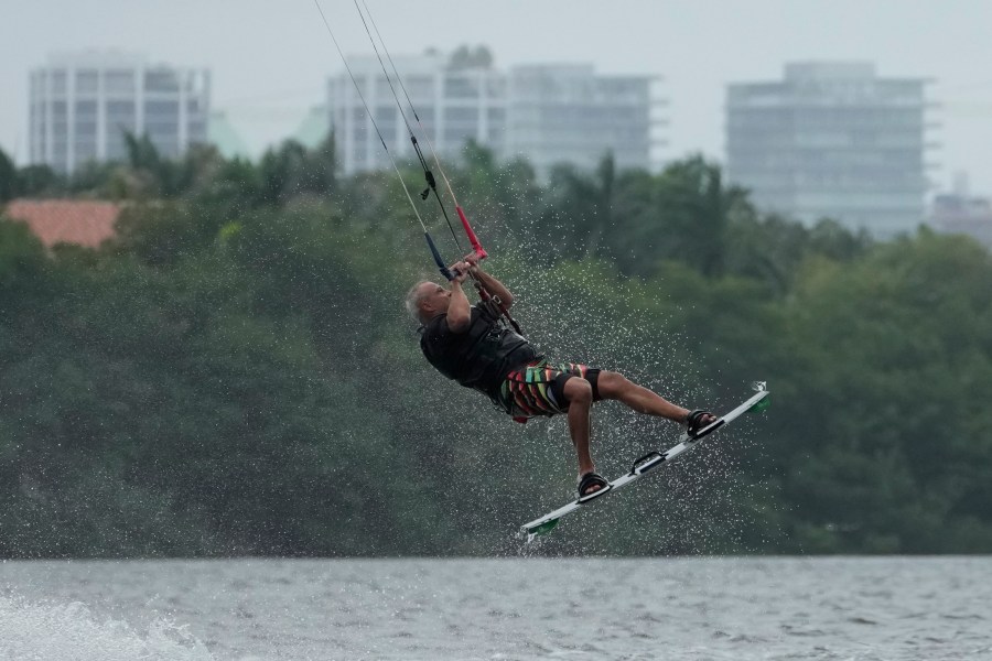
A kite surfer flies in the air as they take advantage of strong winds caused by Hurricane Ian, Tuesday, Sept. 27, 2022, at Matheson Hammock Park in Coral Gables, Fla. (AP Photo/Rebecca Blackwell)


