
Helene now a Category 1 hurricane as it moves over Gulf toward Florida
- Helene expected to make landfall in Florida on Thursday as major hurricane
- Tropical storm was southwest of Cuba on Wednesday
- Thousands along Florida's west coast advised to evacuate
ovp test

Male shot by female at Shreveport apartment

Class to create biodiverse backyard

Rules for outbursts at Caddo School Board Meeting

(NewsNation) — Helene strengthened into a Category 1 hurricane Wednesday as it moved over the Caribbean into the Gulf of Mexico toward Florida.
Floridians along the peninsula’s west coast have been preparing for another hurricane forecast to bring strong winds and dangerous flooding as soon as Thursday across the Gulf Coast.
What was a tropical storm early Wednesday morning continues to strengthen ahead of its anticipated landfall in the United States on Thursday. Helene is anticipated to be the fourth hurricane to make landfall in the U.S. this year.
Thousands along Florida’s coast have been advised to evacuate as Helene approaches — especially those living in areas previously hit hard by recent hurricanes.
Brad Reinhart, a senior hurricane specialist, said in a phone interview with the Associated Press that Helene could become a Category 3 by the time it reaches the Gulf Coast.
“People in the Florida Panhandle and the west coast of Florida certainly need to pay close attention,” Reinhart said. “It’s a pretty aggressive forecast for intensification over the next few days. … People need to remain on high alert.”
Tracking Helene’s movement in the Gulf
As of Wednesday morning, Helene was about 500 miles southwest of Tampa, Florida, with maximum winds of 80 mph.
Helene, which formed Tuesday in the Caribbean, is expected to move over deep, warm waters, fueling its intensification. People in regions under hurricane warnings and watches should be prepared to lose power and should have enough food and water for at least three days, forecasters warned.
President Joe Biden declared an emergency in Florida and deployed Federal Emergency Management Agency teams to Florida and Alabama to support local first responders. Federal authorities were positioning generators, food and water, along with search-and-rescue and power restoration teams, the White House said.
Florida Gov. Ron DeSantis has declared a state of emergency in 41 counties. On Tuesday morning, the storm moved through the Caribbean Sea near Cuba and the Cayman Islands, according to the National Hurricane Center.
“Prepare that it’s going to be as strong as possible,” DeSantis said. “The wind you can hide from … it’s the water that can be really, really devastating if you remain there when you’re told to evacuate.”
The storm is anticipated to be unusually large and fast-moving, meaning storm surges, wind and rain will likely extend far from the storm’s center, the hurricane center said. States as far inland as Tennessee, Kentucky and Indiana could see rainfall.
Watches and warnings issued for Helene
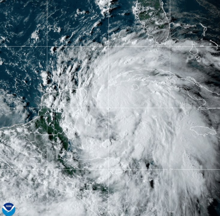
This National Oceanic and Atmospheric Administration satellite image taken at 6:10pm ET shows Tropical Storm Helene off the Gulf Coast of Florida near Mexico and Cuba on Tuesday, Sept. 24, 2024. (NOAA via AP) 
Sandbags are filled at a public site while residents prepare their homes for potential flooding, Tuesday, Sept. 24, 2024, in Tarpon Springs, Fla., as Tropical Storm Helene approaches. (Douglas R. Clifford/Tampa Bay Times via AP) 
Karl Bohlmann, left, and Tangi Bohlmann, of Tarpon Springs, collect sandbags at a public site while residents prepare their homes for potential flooding, Tuesday, Sept. 24, 2024, in Tarpon Springs, Fla., as the Tropical Storm Helene approaches. (Douglas R. Clifford/Tampa Bay Times via AP) 
Residents Dennis Lusby, left, and John Guerra fill sandbags at the Orange County distribution site at Barnett Park in Orlando, Fla., Tuesday, Sept. 24, 2024, ahead of the forecast for the possibility of heavy rains in Central Florida. (Joe Burbank/Orlando Sentinel via AP) 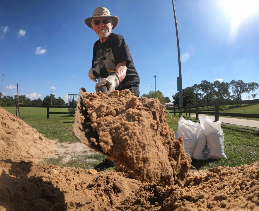
Denis Keeran, of Maitland, fills sandbags at the Orange County distribution site at Barnett Park in Orlando, Fla., Tuesday, Sept. 24, 2024, ahead of the forecast for the possibility of heavy rains in Central Florida. (Joe Burbank/Orlando Sentinel via AP) 
Justin Fogle, of College Parks, fills a sandbag at the Orange County distribution site at Barnett Park in Orlando, Fla., Tuesday, Sept. 24, 2024, ahead of the forecast for the possibility of heavy rains in Central Florida. (Joe Burbank/Orlando Sentinel via AP) 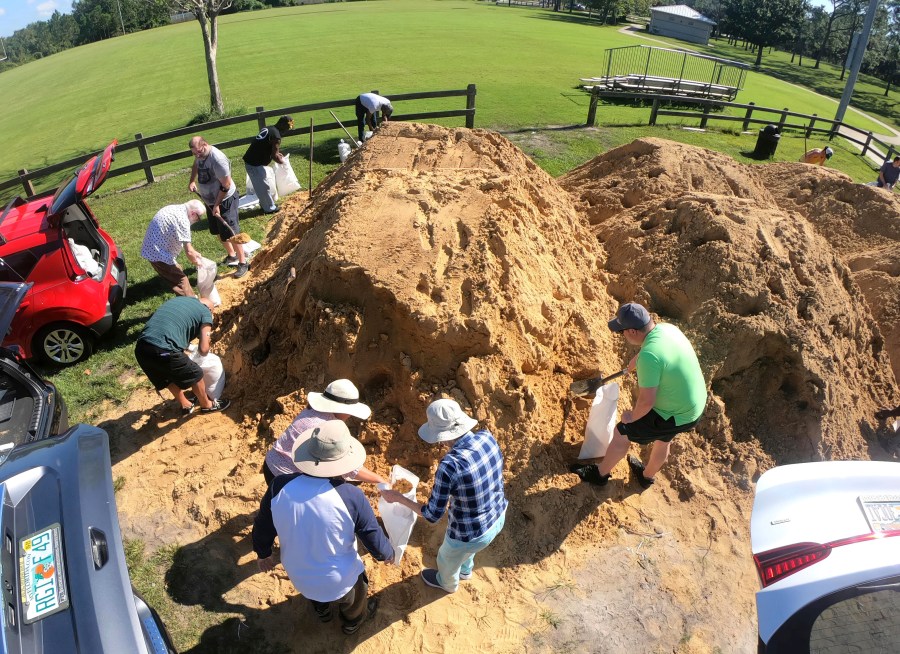
Residents fill sandbags at the Orange County distribution site at Barnett Park in Orlando, Fla., Tuesday, Sept. 24, 2024, ahead of the forecast for the possibility of heavy rains in Central Florida. (Joe Burbank/Orlando Sentinel via AP) 
A person walks in the rain after the passing of Hurricane John in Marquelia, Mexico, Tuesday, Sept. 24, 2024. (AP Photo/Luis Alberto Cruz) 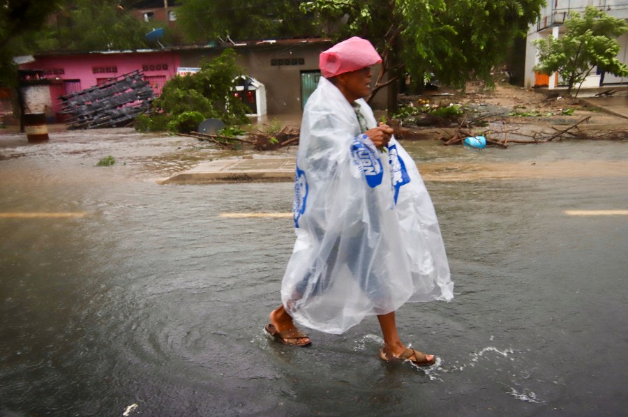
A person wearing plastic walks in the street after the passing of Hurricane John in Marquelia, Mexico, Tuesday, Sept. 24, 2024. (AP Photo/Luis Alberto Cruz)
Watches and warning have been issued for parts of the Yucatan Peninsula, western Cuba, Grand Cayman and Florida, according to the Weather Channel.
A hurricane warning was in effect for the Anclote River to Mexico Beach, Florida; and Cabo Catoche to Tulum, Mexico including Cozumel.
A hurricane watch is in effect for the Cuban province of Pinar del Rio; and in Florida, from Englewood to Anclote River, including Tampa Bay. Hurricane watches mean that hurricane conditions are possible. They are usually issued 48 hours before forecasters predict the first occurrence of tropical storm-force winds.
In Florida, a storm surge warning was in effect for Indian Pass southward to Flamingo; Tampa Bay; and Charlotte Harbor. This means there’s a possibility of life-threatening “inundation” in those areas for the next 36 hours.
The Dry Tortugas; all of the Florida Keys; the Florida west coast from Flamingo to Anclote River, including
Tampa Bay; west of Mexico Beach to the Walton/Bay County Line; the Florida east coast from Flamingo northward to the mouth of the St. Mary’s River; Lake Okeechobee; Rio Lagartos to Cabo Catoche, Mexico; and Cuban provinces of Artemisa, Pinar del Rio, and the Isle of Youth are under a tropical storm warning. A tropical storm warning indicates tropical storms conditions are expected in the next 24-36 hours.
The Georgia and South Carolina coasts north of the mouth of the St. Mary’s River to the South Santee River are under a tropical storm watch, so these conditions are possible in the areas within 48 hours.
In the coming days, people in regions under storm watches and warnings should be prepared to lose power, Lisa Bucci, a hurricane specialist, told AP. Bucci added that those in affected areas should stock up on enough food and water for at least three days.
“Now is the time to start preparing. If you’re in an evacuation zone, you should evacuate,” Bucci said. “Don’t be fooled by the way the storm looks at the moment. We are expecting it to rapidly intensify.”
The Associated Press contributed to this report.


