What is the heat index, and how does it vary from air temperature?
ROCHESTER, N.Y. (WROC) — Throughout the summer, much of the country has experienced at least a few days of extreme heat.
In some cases, Americans were seeing large differences between real and ‘feel-like’ temperatures. In Rochester, New York, for example, high temperatures were only reaching the mid-90s during a multi-day stretch of heat but the ‘feel-like’ temperatures were nearing the triple-digits.
This ‘feel-like’ temperature can be identified as the heat index, but how could the heat index temperatures be warmer than the actual air temperature?
Air temperature can be a tricky thing, especially when there are multiple variables in the air that have an effect on temperature and the way it feels.
Having an air temperature under dry conditions is one story, but feeling that same temperature in a much more humid atmosphere can make the actual temperature feel a whole lot hotter and more uncomfortable than it actually is.
According to the National Weather Service (NWS), the heat index is the apparent temperature — or the temperature perceived by humans — that the body feels due to the combination of abnormally high air temperature and high relative humidity.
The index, which heavily relies on the amount of moisture in the air, was developed by Robert G. Steadman in 1979 after various studies and analyses. The NWS then performed further analysis to develop an equation that would predict heat index values given the current air temperature and relative humidity.
In order to calculate the heat index, you need to compare the dew point (or relative humidity) values and the actual air temperature.
Below is a chart of some of these values:

For example, an air temperature at 85°F with a dew point of 70°F, or 63% relative humidity will actually feel like 90°F. This new value is considered to be the heat index. However, if you have an air temperature of 85°F with a dew point of 60°F and relative humidity of 45%, it will still feel like 85°F. The heat index can even be lower than the temperature with a low enough relative humidity. You can calculate the heat index yourself by clicking here.
The heat index can have an impact on your body.
When your body gets hot, its natural response is to sweat. If there’s a high amount of moisture in the air, it’s harder for the sweat on your skin to evaporate back into the atmosphere. This makes it difficult to regulate your body temperature especially in hot and humid and can take a toll on your body. It is important to listen to your body and know when to take a break from the outdoors in high heat index values.

The table above from NOAA shows what impact heat indexes can have on our bodies. At the lower end, when the heat index is between 80°F-90°F, you may become fatigued after spending an extended period of time outside. Should the heat index surpass 125°F, officials say heat stroke becomes highly likely.
When heat index values reach certain levels, the NWS will activate heat alerts. There are four main alerts — excessive heat warning, excessive heat watches, heat advisory, excessive heat outlooks — but the thresholds for each can vary based on the location.
The outlooks are issued when there is a potential for excessive heat within the next three to seven days, according to the NWS. A heat advisory comes when “extremely dangerous heat conditions” are expected within 12 hours. In most cases, this is used when the maximum heat index is likely to reach triple-digits for at least two days and the air temperature won’t drop below 75°F overnight — this range may, however, vary across the country.
An excessive heat watch is issued when, in the next 24 to 72 hours, the risk of a heat wave is rising but it’s uncertain when it’ll come. Within 12 hours of “the onset of extremely dangerous heat conditions,” an excessive heat warning may be issued. Like a heat advisory, the temperature and heat index criteria for this to be activated can vary but the heat index may exceed 105°F. Without immediate precautions, “you may become seriously ill or even die,” the NWS explains.
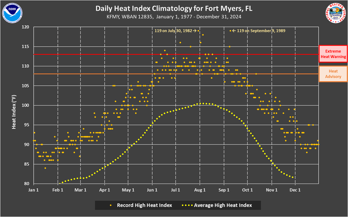
Below is a heat index example from West Central and Southwest Florida, showing record-high heat indexes from 1977 to 2023, as well as the average high heat index:

It also shows when an excessive heat warning is issued (when the heat index reaches about 113°F) and a heat advisory (around 108°F) by the NWS Tampa Bay office.
The NWS recently launched its HeatRisk tool, which follows a five-point scale that ranks the risk of heat-related impacts nationwide. It takes into account how unusual the high temperatures are for the time of year, how long the heat will last through the day and night, and if the temperatures “pose an elevated risk of heat-related impacts” according to data from the Centers for Disease Control and Prevention. You can check that here.


