
(NewsNation) — Hurricane Ian weakened to a Category 1 storm Wednesday night as it moved inland and battered the central part of the state after making landfall just after 3 p.m. local time as a Category 4 hurricane on the southwest coast near the heavily populated Fort Myers area.
Maximum sustained winds at one point Wednesday reached 155 mph, only 2 mph short of intensifying to a Category 5 storm with higher wind gusts, the National Hurricane Center said. As of 11 p.m., maximum sustained winds were at 90 mph.
More than 2 million households in Florida were without power Wednesday evening, according to PowerOutage.us. The outages were widespread but concentrated heavily in the southwest portion of the state where the hurricane first hit.
Hurricane Ian made landfall in the nearly identical spot as Hurricane Charley in 2004. But Charley was smaller — so much smaller that the entire hurricane could fit inside just the eye of Hurricane Ian. Weather Channel meteorologist Stu Ostro tweeted a picture of Charley superimposed on Ian.
11:52 p.m. CT: Emergency crews dispatch in Manatee County
Emergency crews in Manatee County began mobilizing for recovery efforts, delivering fuel to shelters for generators and working to restore wastewater service. Manatee County includes the city of Bradenton, south of Tampa.
10:49 p.m. CT: Jacksonville airport cancels all Thursday flights
The Jacksonville International Airport in Florida has cancelled all Thursday flights due to Hurricane Ian. The airport terminal will also be closed.
Airport officials advise travelers to contact their airline for rebooking options.
10:15 p.m. CT: Hurricane Ian weakens to Category 1
Just before 10:15 p.m. Hurricane Ian was downgraded to a Category 1 storm.
9:45 p.m. CT: DeSantis tells Floridians to continue seeking shelter, heed local weather warnings
Florida Gov. Ron DeSantis issued a statement Wednesday night asking Floridians to continue seeking shelter and heeding their local weather warnings until Hurricane Ian has passed through the state Thursday afternoon. DeSantis noted the power of Hurricane Ian, which brought winds of 155 mph, 2 mph short of a category 5 level storm. Storms surges reached 18 feet high in some parts of the state.
9:30 p.m CT: National Weather Service warns of higher rainfall total
The National Weather Service informed local sheriff’s offices Wednesday night some parts of Florida could see up to 30 inches of rain, according to Volusia County Sheriff Mike Chitwood. Projected rainfall totals have continued to rise as the storm makes its way across Florida, rising from 10 to 15 inches, to the the new 30-inch total issued by the NWS.
9:28 p.m. CT: 2 million households left without power
More than 2 million households in Florida are without power, according to PowerOutage.US. Hurricane Ian, which is expected to continue scraping slowly across the state through the night, has rendered emergency response crews in some parts of the state unable to respond to calls until early Thursday morning.
8:52 p.m. CT: Hurricane Ian downgraded to Category 2
Just before 9 p.m. Wednesday, Hurricane Ian was downgraded to a Category 2 storm.
A wind tower near Punta Gorda recently recorded winds of 55 mph with a wind gust of 78 mph. An automated station at the Punta Gorda Airport measured a wind gust of 109 mph just before 8 p.m.
The National Hurricane Center says Ian is continuing to batter the Florida peninsula with catastrophic storm surge, winds and flooding.
8:10 p.m. CT: 20 Cuban migrants missing
Before Hurricane Ian made landfall in Florida, four Cuban migrants swam to the Florida Keys shoreline Wednesday and three others were saved after their boat sank. Now, officials say 20 more Cuban migrants might be missing.
According to U.S. Customs and Border Protection Chief Patrol Agent Walter Slosar, the first group of four Cubans made it to an area east of Key West. They reported that their boat sank due to the weather.
That’s when the U.S. Coast Guard started looking for 23 missing people. They ended up rescuing three people and rushing them to a local hospital.
Crews have continued to search by air for the migrants that are still missing.
7:45 p.m. CT: “This is real, and devastating, for all of us.”
As the Lehigh Acres Fire Control & Rescue District waits out Hurricane Ian, the department said many of their firefighters are learning that they no longer have homes to return to after the storm.
“This is real, and devastating, for all of us in southwest Florida,” Lehigh Acres Fire Control & Rescue District tweeted.
The department urged community members to stay inside their homes as Hurricane Ian passes, saying their response becomes more difficult when people leave their homes and become trapped or injured.
7:30 p.m. CT: States answer Florida’s call for help
Florida Gov. Ron DeSantis says 26 states have answered their call for help with Hurricane Ian. The governor specifically thanked leaders from Tennessee, Alabama and Louisiana.
“Florida is grateful,” DeSantis tweeted.
According to DeSantis, Alabama Gov. Kay Ivey is sending Black Hawk helicopters to Florida, while Louisiana Gov. John Bel Edwards sent members of the Louisiana National Guard.
At least 5,000 Florida Guardsmen have been activated in response to Hurricane Ian.
Here’s how you can help.
6:10 p.m. CT: Key West airport to reopen
Key West International Airport will reopen at 7 a.m. Thursday, the airport announced. Several others across the state, including Tampa International Airport, remain closed. Key West advised passengers to contact airlines for updates on flight changes and cancellations.
5:20 p.m. CT: Virginia governor declares state of emergency
Virginia Gov. Glenn Youngkin declared a state of emergency in preparation for remnants of Hurricane Ian that are expected to hit the state later this week.
“We want to ensure that our communities have the resources needed to respond to and recover from any potential effects from the storm,” Youngkin said in a statement. “While we recognize that the storm track is still uncertain, I nevertheless encourage all Virginians and visitors to make a plan, have supplies on hand, and follow official sources for the latest forecast information and guidance.”
5:15 p.m. CT: President Joe Biden calls local officials
President Joe Biden has called several local officials to assure communities they have the support of the federal government. Biden called the mayors of Fort Myers, Cape Coral and Sarasota, as well as the chair of Charlotte County, the White House said.
He spoke with Fort Myers Mayor Kevin Anderson and discussed the city’s ongoing needs. Messages were left with the other officials.
4:43 p.m. CT: Gov. DeSantis provides Hurricane Ian update
Gov. Ron DeSantis said Ian will likely be one of the five most powerful storms to hit the state and assured residents that first responders are standing by to help as soon as it’s safe to enter the most affected areas.
The governor also cautioned Floridians in the central part of the state to prepare for hurricane-force winds as the storm is expected to move north in the coming hours and days. Many counties in northeast Florida near Jacksonville have issued mandatory evacuation orders.
DeSantis said emergency crews would dispatch in communities along the western coast no later than Thursday morning to begin rescue operations when winds subside and floodwaters begin to recede. State meteorologists say the storm surges have likely peaked after hitting 12 feet in some areas.
“This storm is doing a number on the state of Florida,” DeSantis said at an afternoon press conference.
4:16 p.m. CT: Fort Myers issues citywide curfew
The city of Fort Myers has issued an emergency citywide curfew beginning at 6 p.m., which will remain in place for the next 48 hours.
3:35 p.m. CT: Ian makes landfall over mainland Florida
The eye of Hurricane Ian has made landfall on the mainland southwest Florida peninsula just south of Punta Gorda near Pirate Harbor, according to the National Hurricane Center.
Maximum sustained winds at landfall were estimated to be 145 mph.
3:33 p.m. CT: Carolinas declare state of emergency
South Carolina Gov. Henry McMaster and North Carolina Gov. Roy Cooper have both declared a state of emergency ahead of Hurricane Ian’s advance north. The emergency declarations allow the states to mobilize resources and more efficiently allocate supplies.
3:10 p.m. CT: 124 mph wind gusts at Punta Gorda airport
The Punta Gorda airport, which is about 25 miles north of Fort Myers, recently reported a wind gust of 124 mph, according to the National Hurricane Center.
A station at the Cape Coral fire department also reported a wind gust of 110 mph.
3:03 p.m. CT: More than 1 million households without power statewide
A total of 1,031,722 customers were without power in Florida Wednesday afternoon, according to PowerOutage.US. The most outages were reported in Lee County, where 338,948 households were without power.
2:10 p.m. CT: Ian makes landfall over Southwest Florida
Hurricane Ian has made landfall near Fort Myers, Florida, according to the National Hurricane Center. The NCH reported maximum sustained winds of 150 mph at the time of landfall.
Additionally, an Extreme Wind Warning has been re-issued on the coast for the backside of Ian’s eyewall, which is expected to be the most intense part of the storm, with winds in excess of 120 mph.
2 p.m. CT: Bryan County, Georgia, declares state of emergency
Bryan County has declared a state of emergency in anticipation of potential impacts of Hurricane Ian.
“In the event of hurricane damage, the emergency declaration allows the Bryan County Board of Commissioners to have the necessary tools to respond quickly and ensure a speedy recovery. This also allows the County to request resources such as equipment and money for response and recovery, if necessary,” the county wrote in a Facebook post.
Georgia Gov. Brian Kemp has signed a similar declaration for the state that opens up resources and aims to prevent price gouging.
1:42 p.m. CT: More than 600K without power statewide
A total of 668,053 customers were without power in Florida Wednesday afternoon, according to PowerOutage.US. The most outages were reported in Lee County, where more than 225,000 people were without power.
1:20 p.m. CT: Manatee County Administrator Dr. Scott Hopes warns of flooding
During a briefing, Hopes said a water storm surge and flooding is yet to come. He encouraged residents to shelter in place and noted that more than 5,120 evacuees are in shelters and schools.
Additionally, seven utility teams are staged at strategic locations throughout the county to aid in recovery. There were about 25,000 power outages reported and 4,300 restored as of 2 p.m. local time.
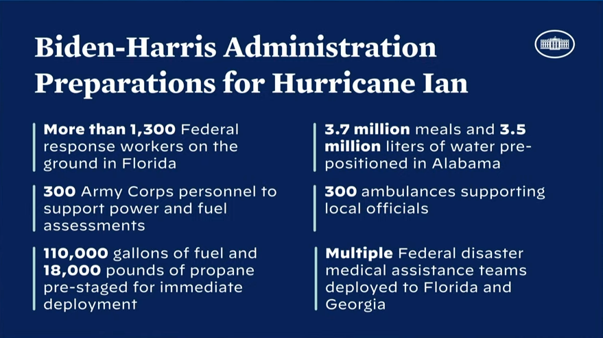
12:55 p.m. CT: White House announces hurricane preparation, Biden FEMA visit
White House Press Secretary Karine Jean-Pierre said during a news briefing that President Joe Biden will visit the FEMA headquarters Thursday for a briefing on Hurricane Ian.
The Biden-Harris Administration also has taken the following hurricane preparation steps:
12:53 p.m. CT: Landfall expected; predicted to decrease in severity
According to NewsNation meteorologist Gerard Jebaily, Hurricane Ian is expected to make landfall in 15 to 20 minutes. He also predicted the hurricane will decrease in severity after it makes landfall.
12:47 p.m. CT: DeSantis requests Major Disaster declaration from Biden
In a press briefing, Florida Gov. Ron DeSantis requested a Major Disaster declaration from President Biden for all 67 counties of the state.
As part of this request, DeSantis also asked that Biden approve a FEMA federal cost share of 60% for 45 days to support recovery efforts in the wake of Hurricane Ian.
This FEMA funding would support debris removal and emergency protective measures to help counties that will be directly impacted by Hurricane Ian. The president has the authority to issue a waiver and increase the federal cost share for hurricane recovery. The approval of this funding has the potential to save Florida communities and the state hundreds of millions of dollars.
12:39 p.m. CT: Ian pushing water out of Tampa Bay
According to NewsNation affiliate WFLA, water along the Hillsborough River in downtown Tampa started receding as Hurricane Ian approached.
Officers with the Tampa Police Department also posted several photos of water receding from the bay.
“The water has receded, a clear sign that Hurricane Ian is drawing near,” the department said.
12:16 p.m. CT: Hurricane conditions spreading across southwestern Florida
Hurricane conditions are now spreading across portions of southwestern Florida, according to the National Hurricane Center.
The Earth Networks Station at the Naples Grande Beach Resort reported a wind gust of 112 mph.
12:11 p.m. CT: Curfew issued, flooded roads in Naples
The City of Naples has issued an emergency citywide curfew over extremely hazardous conditions on its roadways. The curfew is effective immediately until further notice.
The Naples Fire-Rescue Department posted video and photos on social media of flooded streets in the city.
“Please stay off the roads in Naples until the storm has passed. The roads are unsafe,” the city posted.
12:06 p.m. CT: 200,000 power outages in Florida
In a noon press conference, Gov. Ron DeSantis said there are currently 200,000 power outages reported across Florida and predicted it’s “just a drop in the bucket” for things to come. According to reports, 7,000 people in Tampa alone are without power.
12: p.m. CT: Orlando prepares for flooding
According to a tweet from the City of Orlando, crews are proactively cleaning storm drains, staying out as long as possible to ensure roads stay clear by removing fallen debris as the storm approaches.
11:50 a.m. CT: Ian nears landfall
Hurricane Ian’s extremely dangerous eyewall nears landfall just before 1 p.m. local time as a Category 4 hurricane north of the heavily populated Fort Myers area.
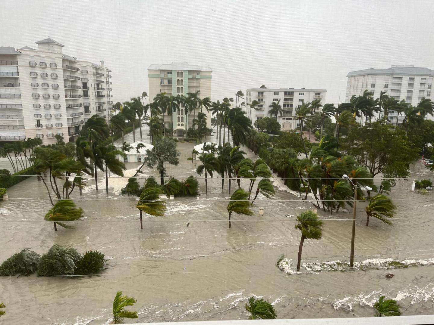
Photo of flood waters caused by Hurricane Ian in the city of Naples Florida, courtesy of the City of Naples, FL Government Facebook page. 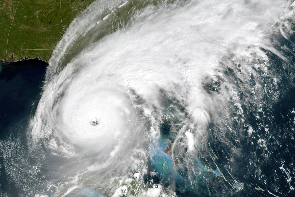
This GOES-East GeoColor satellite image taken at 12:01 a.m. EDT on Wednesday, Sept. 18, 2022, and provided by the National Oceanic and Atmospheric Administration (NOAA), shows the eye of Hurricane Ian approaching the southwest coast of Florida. Hurricane Ian’s most damaging winds began hitting Florida’s southwest coast Wednesday, lashing the state with heavy rain and pushing a devastating storm surge after strengthening to the threshold of the most dangerous Category 5 status. (NOAA via AP) 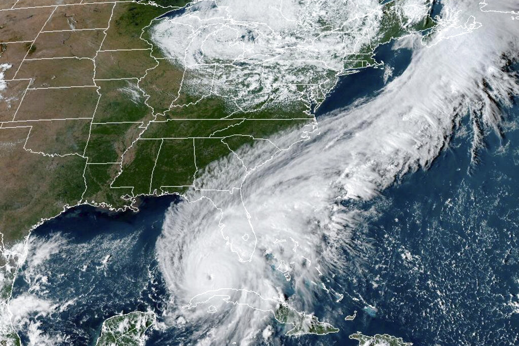
This GOES-East GeoCcolor satellite image taken at 4:26 p.m. EDT on Tuesday, Sept. 27, 2022, and provided by the National Oceanic and Atmospheric Administration (NOAA), shows Hurricane Ian over the Gulf of Mexico. Hurricane Ian tore into western Cuba as a major hurricane Tuesday and left 1 million people without electricity, then churned on a collision course with Florida over warm Gulf waters amid expectations it would strengthen into a catastrophic Category 4 storm. (NOAA via AP ) 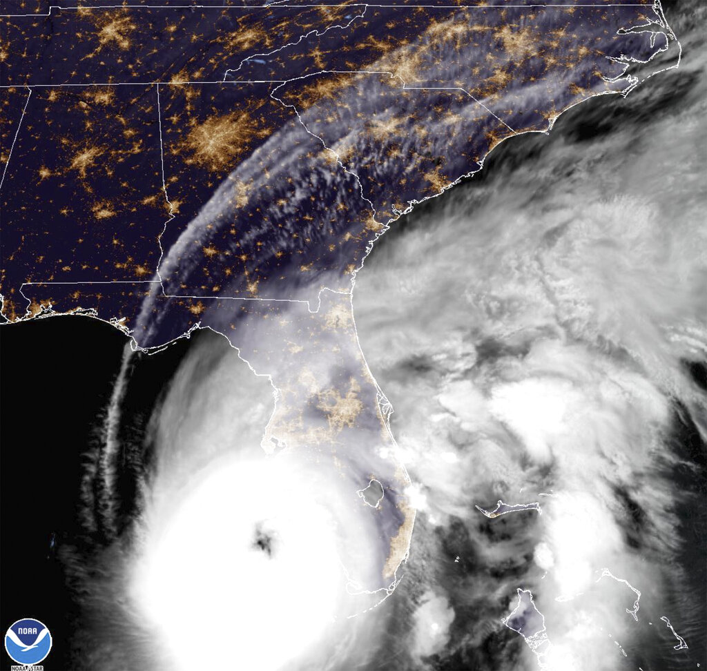
This satellite image provided by NOAA shows Hurricane Ian off Florida’s southwest coast Wednesday, Sept. 28, 2022. The U.S. National Hurricane Center says Ian has rapidly intensified off Florida’s coast, gaining top winds of 155 mph, just shy of the most devastating Category 5 hurricane status. (NOAA via AP) 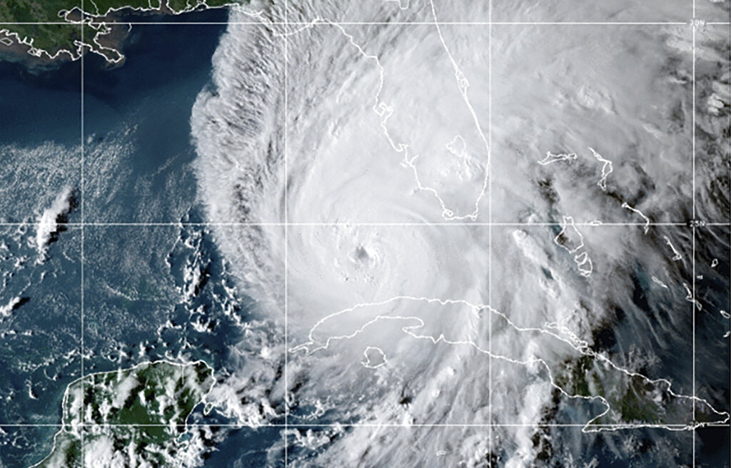
This GOES-East GeoCcolor satellite image taken at 10:10 p.m. EDT on Tuesday, Sept. 27, 2022, and provided by the National Oceanic and Atmospheric Administration (NOAA), shows Hurricane Ian over the Gulf of Mexico. Ian tore into western Cuba as a major hurricane Tuesday, knocking out power to the entire country and leaving millions people without electricity, before churning on a collision course with Florida over warm Gulf waters amid expectations it would strengthen into a catastrophic Category 4 storm. (NOAA via AP) 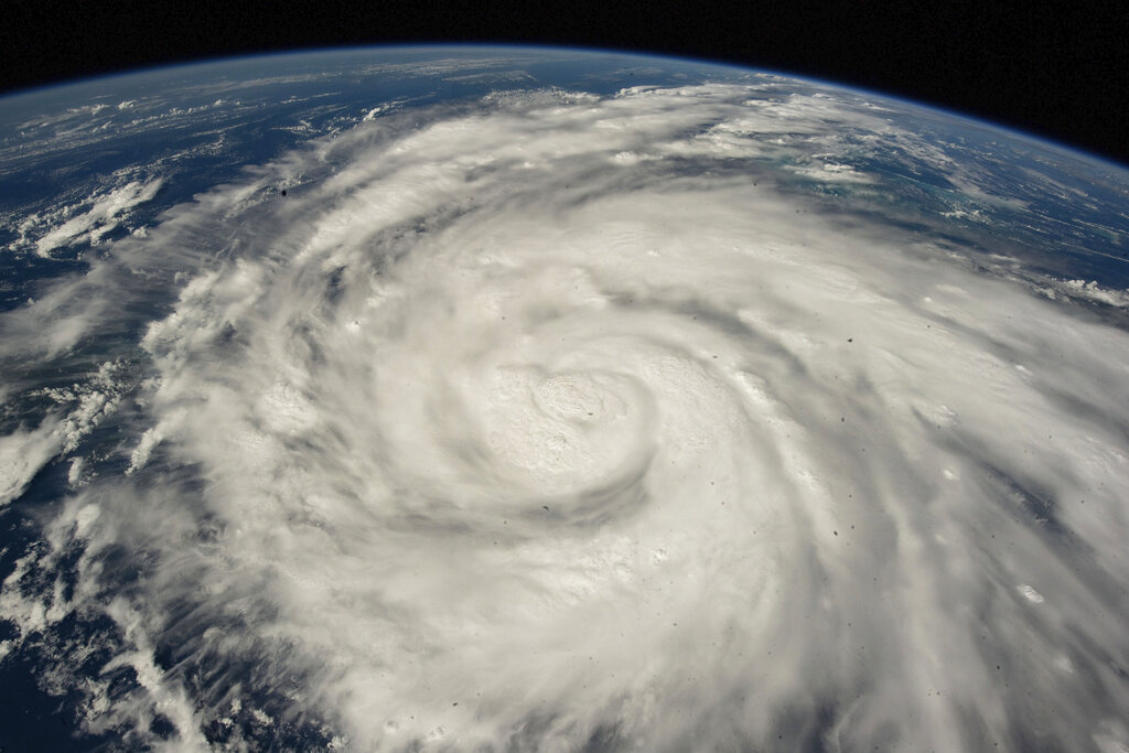
This Satellite image provided by NASA on Sept. 26, 2022, shows Hurricane Ian pictured from the International Space Station just south of Cuba gaining strength and heading toward Florida. Hurricane Ian rapidly intensified off Florida’s southwest coast Wednesday, Sept. 28, gaining top winds of 155 mph (250 kph), just shy of the most dangerous Category 5 status. (NASA via AP) 
This Satellite image provided by NASA on Sept. 26, 2022, shows Hurricane Ian pictured from the International Space Station just south of Cuba gaining strength and heading toward Florida. Hurricane Ian rapidly intensified off Florida’s southwest coast Wednesday, Sept. 28, gaining top winds of 155 mph (250 kph), just shy of the most dangerous Category 5 status. (NASA via AP)
11:43 a.m. CT: Enhanced risk for tornadoes
The National Weather Service Storm Prediction Center warns of an enhanced risk for tornadoes along Florida’s eastern coastline near Daytona and West Palm Beach from Ian’s outer rainbands.
11:39 a.m. CT: Florida Disaster Fund activated
First Lady Casey DeSantis announced the activation of the Florida Disaster Fund to support Florida’s communities impacted by Hurricane Ian.
“The Governor and I are thankful for the graciousness of those looking to assist Florida’s communities in their time of need,” the Florida first lady said. “I am pleased to announce that Volunteer Florida has activated the Florida Disaster Fund so that people can donate directly to those affected by Hurricane Ian. We greatly appreciate the kindness and generosity of organizations and individuals from across the country looking to support Floridians, thank you.”
Here’s how you can help.
11:25 a.m. CT: Extreme wind warning in effect
An extreme wind warning is in effect for Englewood, Rotonda and Grove City until 1 p.m. CDT for extremely dangerous hurricane winds, according to the National Weather Service Tampa Bay.
Treat these extreme winds as if a tornado was approaching and move immediately to an interior room or shelter, the NWS warns.
11:11 a.m. CT: Ian pushes toward shore
Hurricane Ian’s extremely dangerous eyewall is now moving toward shore as a Category 4 hurricane at Sanibel and Captiva islands, according to the National Hurricane Center.
10:55 a.m. CT: Catastrophic wind damage is beginning
Catastrophic wind damage is beginning along the southwestern coast of Florida near the expected landfall location, according to the National Hurricane Center. Hurricane-force winds are expected to extend well inland.
10:46 a.m. CT: 12-18 ft storm surge expected
The National Hurricane Center is predicting a catastrophic storm surge of 12-18 feet above ground level somewhere along the Florida coastline — somewhere between Englewood and Bonita Beach, including Charlotte Harbor.
Residents in those areas should urgently follow any evacuation orders in effect.
10 a.m. CT: Eye about 45 miles west of Naples
Air Force and NOAA hurricane hunters located the eye of the hurricane about 45 miles west of Naples, Florida, moving toward the north-northeast near 9 mph.
9:45 a.m. CT: DeSantis briefing
“It is now a Category 4 hurricane with maximum sustained winds of up to 155 mph — that is knocking on the door of a Category 5 storm,” DeSantis said at a news conference Wednesday morning.
“Don’t go outside in the eye of the storm,” DeSantis warns. “It’s still dangerous. There is actually a calmness if the center of the hurricane is right over you … even if it seems calm, wait to make sure that the storm has actually passed.”
9:45 a.m. CT: Highest at-risk counties
The highest-risk counties are from Collier County up to Sarasota County, and the most recent track has the storm making landfall in Charlotte County.
“If you are in any of those counties, it is no longer possible to safely evacuate,” DeSantis said. “It’s time to hunker down and prepare for this storm. This is a powerful storm that should be treated like you would treat it if a tornado was approaching your home.”
9:16 a.m. CT: Likely tornado produced by outer bands of Ian
Parts of Florida’s east coast faced a storm surge threat as well, and isolated tornadoes were spinning off the storm well ahead of landfall. One tornado damaged small planes and a hangar at the North Perry Airport, west of Hollywood along the Atlantic coast.
9:15 a.m. CT: Cuba begins to restore some power
Cuban officials said they had begun to restore some power Wednesday after Hurricane Ian knocked out electricity to the entire island while devastating some of the country’s most important tobacco farms when it hit the island’s western tip as a major storm. At least two people were reported killed.
The Associated Press contributed to this report.


