
Strong winds in Midwest whip up dust, blow over semitrailers
maylen


OMAHA, Neb. (NewsNation Now) — A powerful storm system swept across the Great Plains and Midwest Wednesday, closing highways in western Kansas, spawning reported tornadoes in Nebraska and Iowa and raising concerns about fires because of unusually high temperatures.
The strong winds whipped up dust that reduced visibility to zero west of Wakeeney, Kansas, the state Department of Transportation said, and caused at least four semitrailers to blow over. Kansas officials closed Interstate 70 from the Colorado border to Russell, as well as all state highways in nine counties in northwest Kansas.
Social media video showed dust and small objects being whipped by the mighty gusts of wind. Trooper Ben Gardner with Kansas Highway Patrol said there were no fatalities in his jurisdiction, but told “NewsNation Prime” that first responders were under a “very significant workload” responding to several crashes.
In Missouri, troopers warned drivers about the wind conditions after a truck rolled over.
The National Weather Service said there have been 13 tornado reports in the Plains states, scattered through eastern Nebraska and Iowa. Winds topped 70 mph through much of Kansas, Nebraska and Iowa.
“To have this number of damaging wind storms at one time would be unusual anytime of year,” said Brian Barjenbruch, a meteorologist with the National Weather Service in Valley, Nebraska. “But to have this happen in December is really abnormal.”
The system came on the heels of devastating tornadoes last weekend that cut a path through states including Arkansas, Missouri, Tennessee, Illinois and Kentucky, killing more than 85 people.
The National Weather Service issued a high wind warning for an area stretching from New Mexico to upper Michigan — including Wisconsin and Illinois. Gusts topping 80 mph were recorded in the Texas Panhandle and western Kansas. The weather service said an automated observation site in Lamar, Colorado, recorded a gust of 107 mph Wednesday morning. Wind gusts of 100 mph were reported in Russell, Kansas.
Greg Butcher, the city administrator in Seward, Nebraska, said he was standing in his office at city hall Wednesday when he saw a giant wall of cloud rolling toward him. Butcher said he braced for a major hit but so far the worst damage appears to be a few toppled telephone poles.
“We lucked out,” Butcher said. “It came in really fast.”

Debris from nearby farm fields swirls around on Highway 400 between Mullinville, Kans., and Dodge City on Wednesday, Dec. 15, 2021. (Travis Heying/The Wichita Eagle via AP) 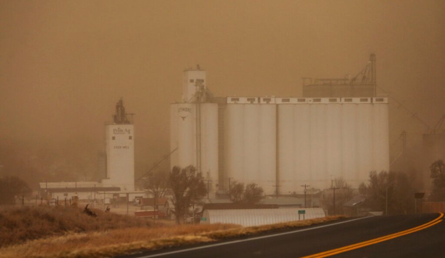
Visibility was less than a half mile in Jetmore, Kans., on Wednesday, Dec. 15, 2021. (Travis Heyingkswie= 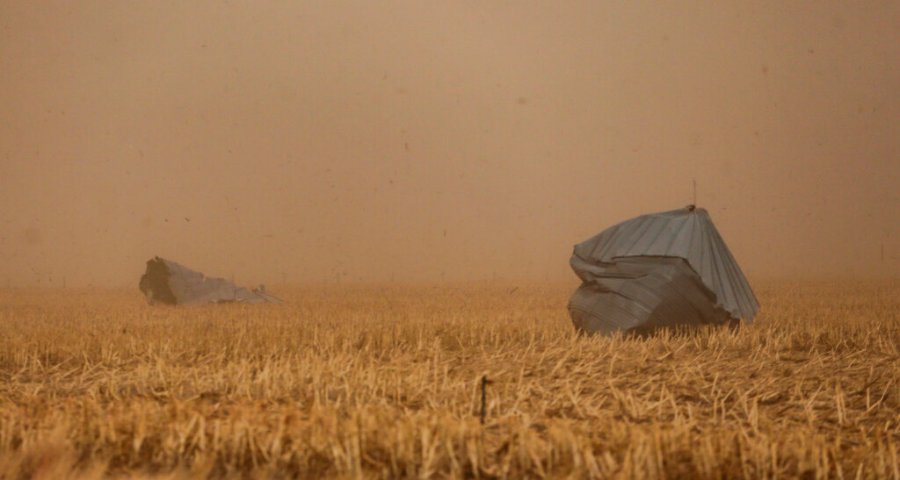
The Hodgeman County Undersheriff confirmed these grain bins were blown away from a nearby farm into cornfield across Hwy 283 on Wednesday, Dec. 15, 2021, in Jetmore, Kans. (Travis Heying/The Wichita Eagle via AP) 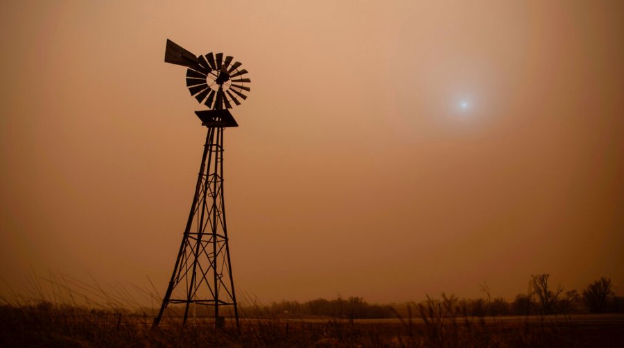
The dust from heavy winds obscures the sun in Hodgeman County in Jetmore, Kans., Wednesday, Dec. 15, 2021. (Travis Heying/The Wichita Eagle via AP)
Officials also warned of a dangerous fire risk along the western edge of the weather system, where conditions were dry.
A wildfire prompted Sheridan County officials to evacuate a few homes near Quinter in northwest Kansas. Emergency management director Don Koerperich did not have an estimate of how big the fire was, but said “I’m glad it wasn’t near any towns.” Other fires were reported in Russell and Ellis counties.
Scientists say extreme weather events and warmer temperatures, much like what’s happening, are more likely to occur with human-caused climate change. However, scientifically attributing a specific event like this storm system to global warming requires specific analysis and computer simulations that take time, haven’t been done and sometimes show no clear connection.
“I think we also need to stop asking the question of whether or not this event was caused by climate change. All events nowadays are augmented by climate change,” said Northern Illinois University meteorology professor Victor Gensini. “We need to be asking, `To what extent did climate change play a role and how likely was this event to occur in the absence of climate change?’”
The unusually warm temperatures on Wednesday were due in part to ocean temperatures in the Gulf of Mexico being at record-warm levels, which wouldn’t have happened without global warming, said Jeff Masters, a Yale Climate Connections meteorologist Jeff Masters, who cofounded Weather Underground.
“That record heat is helping feed heat and moisture into today’s storms, increasing their damage potential,” he said.
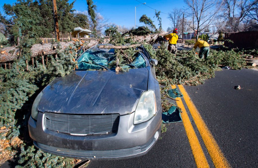
Damaging winds were likely to bring down trees and power lines, leading to power outages, the National Weather Service warned. Some schools in Kansas, Nebraska and Iowa either canceled in-person classes or closed early.
Officials in Ashland, Kansas, shut down the town’s power supply for a few hours to reduce the threat of fire after multiple power poles were knocked down.
In Chicago, strong winds toppled trees and damaged vehicles in the city’s Andersonville neighborhood. A high wind warning is scheduled to expire Thursday morning, according to the National Weather Service.
The system blew into the Plains from Colorado, where high winds knocked out power, closed roads and highways and delayed or canceled hundreds of flights.
In the Southwest, strong winds took down power lines in Shiprock, New Mexico, knocking out power to residents across the Navajo Nation. The weather service said a wind gust of 100 mph was recorded on the airfield at the Air Force Academy in Colorado Springs.
Blaire Brush, a spokeswoman for the military academy, said windows on multiple cars and buildings were shattered during the windstorm. She did not know if the windows were smashed by objects flung by the wind or from the force of a gust.
On nearby Interstate 25, more than a dozen semitrailers blew over in winds that topped 90 mph. according to the Colorado Springs Gazette.
In the Southwest, strong winds took down power lines in Shiprock, New Mexico, knocking out power to residents across the Navajo Nation.
Blowing dust drastically cutting visibility in the Texas Panhandle, where Sherman County Sheriff Ted Allen said all roads in and out of the county were closed. In the Oklahoma Panhandle, the state Department of Transportation reported the main road north from Boise City into Colorado was closed because of collisions and downed power lines.
The winds and storms were expected to move quickly east, Thies said. After that, forecasters expect temperatures to plunge, with below freezing temperatures in the northern Plains.
Stafford reported from Liberty, Mo. Associated Press writers Ken Miller in Oklahoma City; Terry Wallace in Dallas; Seth Borenstein in Washington D.C.; and Jim Anderson in Denver, contributed to this report.


